

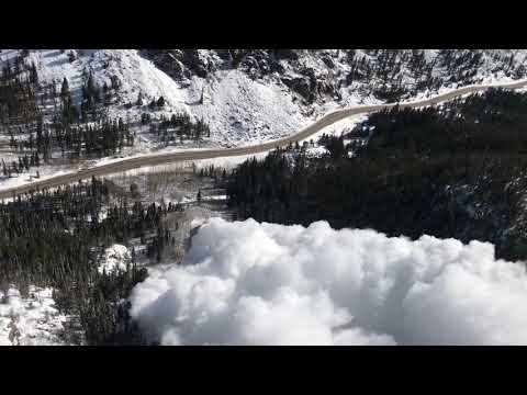
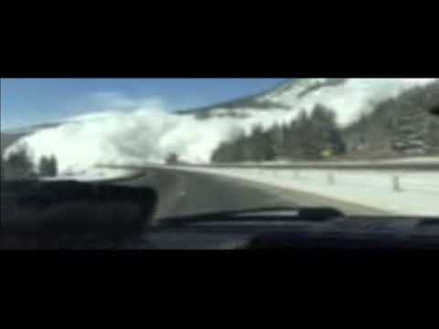
Dramatic dashboard recordings over the weekend of avalanches along Interstate 70 between Frisco and Copper Mountain have stoked anxiety among Coloradans about the safety of the state’s high country roadways sitting beneath avalanche chutes.
But experts say the slides are the result of historic conditions that have been lining up for the entire snow season, setting off avalanches in areas that haven’t released so ferociously in decades.
The recent storm cycle — with another on the way — is stressing weak layers buried deep in a statewide snowpack measuring well over 100 percent of average across the state, creating an avalanche cycle that experts have not seen in years. Even lifetimes.
“It’s not just one storm that does it. It’s the straw that breaks the camel’s back,” said a weary Ethan Greene, who as director of the Colorado Avalanche Information Center guides a team of 18 forecasters across the state who advise the Colorado Department of Transportation and backcountry travelers about avalanche risks.
MORE: A declining number of avalanche deaths in Colorado, the West in the past four seasons buoys hope
Take the Disney chute above Empire. The last time it slid onto U.S. 40, the avalanche path had a different name.
It was April 1957 when the namesake movie company approached the Colorado Highway Department about filming an avalanche for a documentary. They chose the basin on the east side of Berthoud Pass because slides there never reached the road.
But with 79 inches of snow in the previous week, the controlled slide went huge, killing Disney Studios freelance cameraman John Hermann and highway department supervisor Wayne Whitlock. It’s been called Disney ever since.
On Tuesday, officials dropped explosives into the massive basin, its summit more than 6,000 feet away from the roadway and, for the first time since that fateful day in 1957, sliding snow buried the highway.
On Sunday, Greene blasted the relatively small basin beneath Mount Bethel — northeast of the Eisenhower-Johnson Memorial tunnels near Herman Gulch — with seven rounds from CDOT’s WWII-era Howitzer. Nothing happened.
On Tuesday he dropped a couple of big explosives — 35-pound bags of AN/FO, ammonium nitrate/fuel oil — into the area from a helicopter and it ripped to the ground, burying the highway and closing both the westbound and eastbound lanes for much of the day.
“The stuff I saw today, you don’t see that very often in your career,” said Greene, who has directed CAIC since 2005. “Some of these more recent storms with high-precipitation rates, they are just loading everything faster than normal, and it’s not giving these slopes a chance to adjust. When you have a weak layer on the ground and strong mudpack layer on top of that and then a big storm comes in fast, at least fast for us, that’s the recipe for these larger avalanches.”
Copper Mountain was reporting 44 inches of snow in the past 72 hours on Tuesday, while Aspen Snowmass had about 40 inches across its four mountains. Winter Park Resort tallied 32 inches and 38 inches fell at Wolf Creek Ski Area.
The avalanche danger — typically divided into regional zones across the state — is stretching across those zones, with wetter, intense snow storms layering heavy snow on a deep snowpack sitting atop a weak layer. Large, destructive, road-burying and sometimes naturally-occurring avalanches have been reported from Berthoud Pass through Summit County into Gunnison County and on both Wolf Creek and Red Mountain passes in southwest Colorado.

The “historic avalanche cycle” started in October and November, when Colorado got a lot of early-season snow. That snow rotted into facets: imagine ball bearings or sugar-like snow that can’t be formed into a snowball. That’s the weak layer. Then came lots more snow. In the past month, CAIC forecasters started seeing fewer avalanches releasing on that weak layer on the ground.
Then came even bigger storms — like this past weekend when 40 inches fell in two days in the Central Rockies, or the 50 inches that piled up in 50 hours in the Four Corners area two weeks ago. And the slab grew even larger and heavier, all sitting atop the weak layer on the ground. That means every falling flake boosted the chance of a catastrophic slide. And in this latest round of storms, the final flake fell on slide paths above I-70.
“This last set of storms over the last five days, that was pretty intense. Lots of snow with high-precipitation rates and some wetter, denser snow. It’s really good at building slab material and it just pushed it over the edge. That’s the nature of these historic avalanche cycles,” Greene said. “A lot of different factors are coming together right now.”
“It’s not a perfect science”
The Colorado Department of Transportation works every day during the snow season with the avalanche information center to mitigate risk. On Monday and Tuesday, with a new storm bearing down, they attacked avalanche hazard with a flurry of explosives.
That led to major slides across I-70, Berthoud Pass and Red Mountain Pass.
“This is a partnership that’s been going on for many years and has been fairly successful,” Greene said.
That partnership includes the use of French-made Gazex and O’bellx remote avalanche control systems on Loveland Pass’ Seven Sisters and Berthoud Pass’ Stanley slide paths, which set off concussive blasts during and after snowstorms to release avalanches when the roads are clear of motorists. Ideally, the smaller, consistent blasts prevent massive slides after large accumulations of snow.

But the Gazex and O’bellx systems aren’t in every slide path in the state, and the weekend storm dropped deep snow in areas that aren’t typically monitored as closely, like Tenmile Canyon along I-70.
“Some of these haven’t run in 30 to 40 years,” said Bob Wilson, a Colorado Department of Transportation spokesman. “I think the last one that ran in Tenmile Canyon was in (the 80’s).”
Eventually, a wave of snow building all season and weighed down from the weekend’s storm came rocketing down toward motorists on Sunday evening, burying several cars. No one was hurt in the naturally occurring avalanche.
“First it was just a big cloud coming down the mountain, then it just turned totally white,” Colin Rafferty, whose truck was pushed off the interstate by the avalanche, told television station CBS4. “Then it covered our windshield with a couple inches of snow, so the windshield wipers wouldn’t move it.”
Wilson says avalanches are simply part of mountain driving, just like rockslides and mudslides. CDOT’s assessment of geologic hazards along the I-70 corridor in 2011 identified three sections of I-70 spanning 56 miles as threatened by avalanches, from Silver Plume to Dowd Junction, west of Vail. CDOT does its best to keep avalanches at bay — and unplanned ones are extremely rare — but sometimes they can sneak through.
“We do the best we can,” he said, “but it’s not a perfect science.”
With more snow coming — March is Colorado’s snowiest month — CDOT officials are hopeful there won’t be a repeat performance of the avalanches that closed roads and spooked motorists over the past three days.
“We’re going to be staying on top of it as well as we can and hopefully we don’t have a replay of what occurred,” Wilson said.
It’s hard to say what will happen to avalanche hazards as the winter continues and the spring unfolds. Greene said his team is “thinking very hard” about the conditions they are seeing and how to assess the danger for both CDOT and backcountry travelers. He’s trying to share as much as he can so Coloradans understand the nature of these avalanche cycles.
“With these historic events, it gets challenging to say exactly how this will go from here,” Greene said. “Looks like we are going into another stormy period. I do expect we will be very busy in the future.”